In land navigation, surveying, and maritime travel, the terms "azimuth" and "bearing" are frequently used interchangeably. While they both describe an angle of direction relative to a reference point, there are distinct technical differences in how they are measured and written. Understanding these differences is crucial for accurately charting a course on a topographic map.
What is an Azimuth?
An azimuth is strictly defined as the angle measured horizontally and clockwise from a reference plane (almost always True North or Magnetic North) in a full 360-degree circle. It is a single, absolute number that leaves no room for ambiguity.
- Starting Point: Always North (0°).
- Direction: Always measured clockwise.
- Range: 0° to 360°.
- Format: Usually written as a three-digit number. For example, East is 090° and West is 270°.
What is a Bearing?
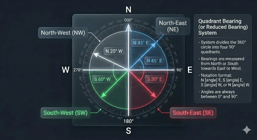
A bearing can sometimes refer to an absolute 360-degree angle (like an azimuth), but historically in surveying and naval navigation, a bearing is measured using the quadrant system. Instead of a full circle, the compass is divided into four 90-degree slices.
In the quadrant system, you always start at either North or South (whichever is closer to your target), and measure up to 90 degrees toward East or West. For example, an azimuth of 135° is written as a bearing of "South 45° East" (S45°E).
Azimuth vs Bearing: Quick Comparison
| Feature | Azimuth System | Bearing (Quadrant) System |
|---|---|---|
| Reference Point | North Only | North or South |
| Direction of Measurement | Clockwise only | Clockwise or Counter-clockwise (towards East or West) |
| Numeric Range | 0° to 360° | 0° to 90° |
| Example Notation | 315° | N45°W |
How to Convert Bearings to Azimuths
Converting between the two systems requires basic arithmetic depending on which quadrant the bearing falls into. Here are the conversion rules:
- Northeast Quadrant (NE): The azimuth is exactly the same as the bearing angle.
Example: N30°E = 030° Azimuth. - Southeast Quadrant (SE): Subtract the bearing angle from 180°.
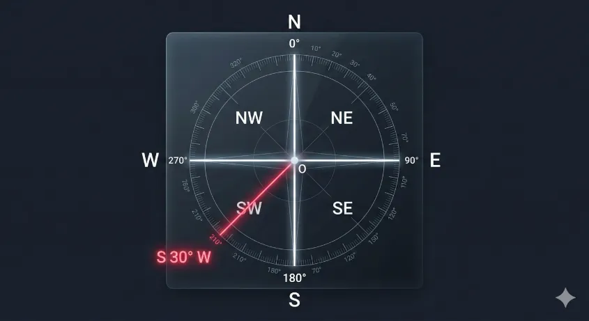
Example: S 30° E → 180° − 30° = 150° Azimuth. - Southwest Quadrant (SW): Add the bearing angle to 180°.
Example: S30°W → 180° + 30° = 210° Azimuth. - Northwest Quadrant (NW): Subtract the bearing angle from 360°.
Example: N30°W → 360° - 30° = 330° Azimuth.
Forward Azimuth vs. Back Azimuth
When navigating, you will also encounter the concept of a back azimuth (or reciprocal bearing). If a forward azimuth is the direction from Point A to Point B, the back azimuth is the exact opposite direction—from Point B looking back at Point A.
To calculate a back azimuth:
- If your forward azimuth is less than 180°: Add 180°.
- If your forward azimuth is greater than 180°: Subtract 180°.
Frequently Asked Questions
Is a heading the same as a bearing?
No. A heading is the direction that your vehicle (or nose) is physically pointing at any given moment. A bearing is the direction of a destination relative to your current position. If wind pushes your boat off course, your heading will be different from your bearing to the target.
Which system is better for land navigation?
The 360-degree Azimuth system is vastly superior for modern land navigation. It is much easier to communicate a single number (e.g., "210°") over a radio than a quadrant bearing (e.g., "South 30° West"), which reduces the chance of dangerous navigational errors.